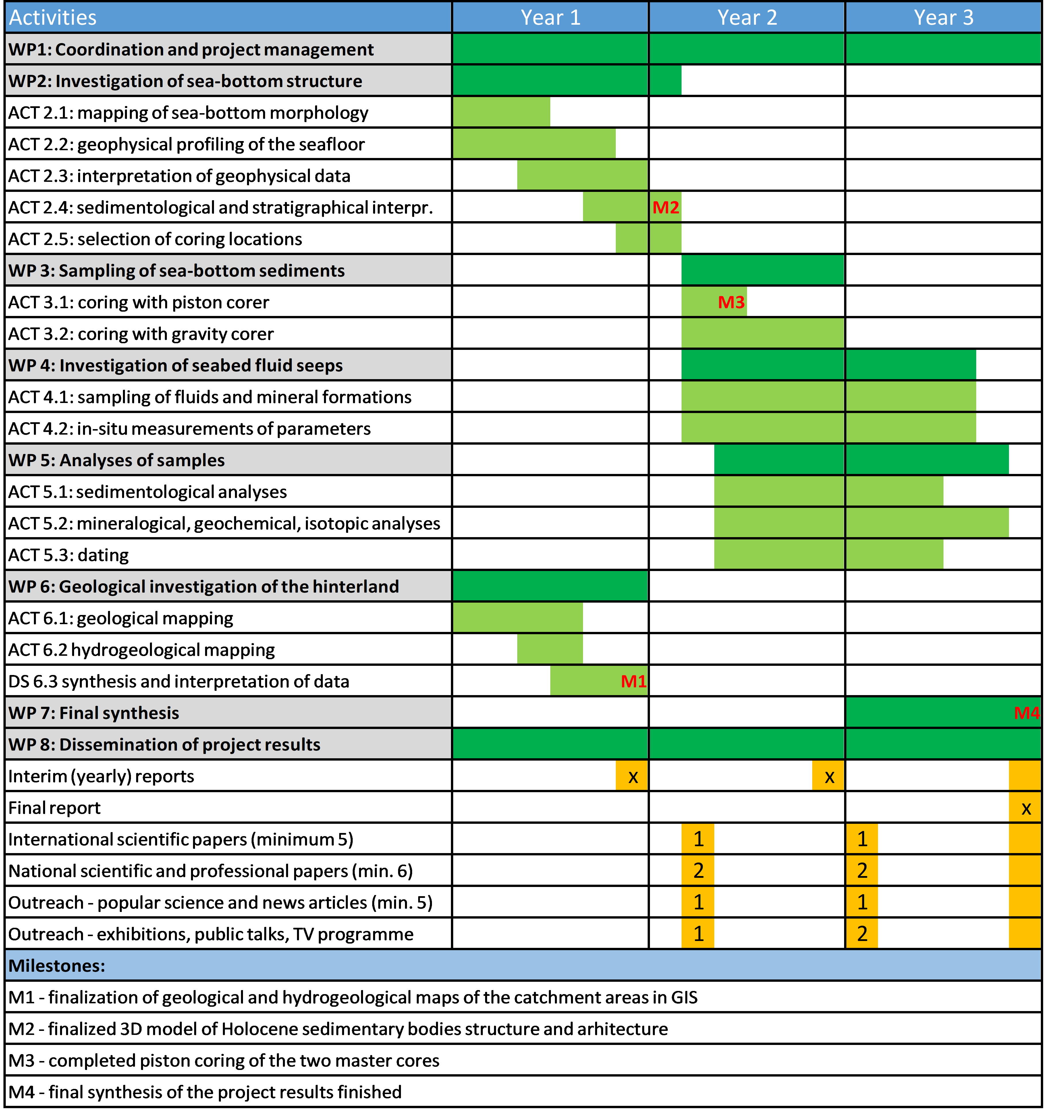
The work programme of the research project is divided into eight work packages (WP), which are further separated into activities (ACT).
WP 1: Coordination and project management (ULNTF, all partners)
ACT 1.1: Administrative management and project control
This activity aims to manage and control the course of the research work in accordance with legislation and contractual obligations. Activity is performed by the project leader and includes communication with the providers and funders of the research project, monitoring and supervision of the activities in accordance with the timetable, and reporting on the progress of the accomplished research. Results of this activity are the archive of correspondence with funders and interim and final reports on the fulfilment of contractual obligations.
ACT 1.2: Coordination of the project team
The aim of this activity is organizational project management and coordination of the project team. Activity is performed by the project leader and includes coordinating the project team, convening and conducting meetings, updating the project team with relevant information regarding the progress of the project and highlighting important milestones of the project. A web platform will be established to facilitate exchange of data and documents among the project team members. Results of this activity are the project management platform, the archive of correspondence within the project team, meeting minutes and other relevant materials.
ACT 1.3: Financial project management and reporting
The aim of this activity is the financial management and reporting in accordance with legislation and contractual obligations. The activity includes management of financial affairs relating to the project; monitoring and supervision of the expenditures in accordance with the financial plan; and the financial reporting of the research project progress. Results of this activity is the archive of financial management and financial reports.
WP 2: Investigation of sea‐bottom structure (ULNTF, Sirio, OGS)
ACT 2.1. Mapping of sea‐bottom morphology with multibeam sonar scanning
The aim of this activity is to create high‐resolution digital models of sea‐bottom topography at selected locations (determined from the existing bathymetric model). This data will provide insight into geomorphic features pre‐ dating transgression which are still recognizable under the blanket of Holocene sediments. This will help in understanding the processes at the transition from continental to marine sedimentation. High‐resolution bathymetry is also important for studying the interactions between sedimentation and erosion on the seabed, and for getting the insight into the dynamics of sea currents, which play a major role in redistribution of sea‐ bottom sediments. Characteristic micro‐relief features visible in the high‐resolution bathymetric model will be used to locate and investigate the sites of submarine springs and associated mineral and biogenic formations.
ACT 2.2: Geophysical profiling of the seafloor
The goal of the activity is to acquire high‐resolution profiles of the seafloor sediment structure with sonar profiling. The acquired profiles will reach for up to 30 m into the seafloor and will include Holocene marine sediments, transitional paralic sediments, and the underlying Pleistocene continental sediments. High resolution of the profiles will allow precise interpretation of the geometry of sedimentary layers and bodies as well as the characterization of their corresponding acoustic facies. In cooperation with the foreign partner OGS we will additionally acquire high‐resolution single‐channel and multi‐channel reflection seismic profiles. The seismic method will allow deeper signal penetration and improved recognition of the deeper stratigraphic horizons.
ACT 2.3: Interpretation of geophysical data and modelling of the seafloor sediment structure
The pre‐existing and newly acquired acoustic geophysical profiles will be processed with seismic processing software in order to enhance the signal‐to‐noise ratio and improve the quality of the profiles. We will migrate the profiles and convert them from time to depth domain. We will analyse and interpret the profiles with the IHS Markit Kingdom software in order to determine the key stratigraphic horizons. We will classify the sedimentary layers according to their acoustic facies and correlate them with sedimentological data from cores. We will create 3D models of stratigraphic horizons and sedimentary bodies with the IHS Markit Kingdom and Paradigm SKUA software.
ACT 2.4: Sedimentological and stratigraphical interpretation of sea‐bottom structure
On the basis of the 2D and 3D geophysical interpretation, the sedimentological and stratigraphical features of Holocene and underlying post‐LGM sediments will be investigated. Using methods of seismic stratigraphy and sequence stratigraphy the principal sedimentary bodies and their internal architecture will be defined and interpreted. From the relative chronology and spatial relationships between the sedimentary bodies we will determine the main sequence boundaries and interpret of the sedimentary evolution of the research area in view of interplay between relative sea‐level changes, variations in input of terrigenous material (climate and anthropogenic impact), and dynamics of erosion and deposition in the Gulf. Additional geophysical profiles will be acquired if needed to clarify any outstanding questions.
ACT 2.5: Selection of coring and sampling locations
We plan to acquire two master cores covering the entire Holocene succession. First core will be taken in the area dominated by terrigenous input and the second core where marine sedimentaton prevails. Optimal coring locations will be selected on the basis of the findings in ACT 2.3 and 2.4., ensuring that a representative, continuous and complete sedimentary record will be obtained. Master cores thus selected will provide a timeframe for correlating the record from additional shallow cores and from sub‐bottom geophysical profiles. From the precise seafloor morphology (ACT 2.1) and sea‐bottom structure (ACT 2.2 to 2.4) we will determine locations for sampling and monitoring of underwater springs and associated mineralizations.
WP 3: Sampling of sea‐bottom sediments (ULNTF, Sirio, MBP, HGI)
ACT 3.1: Coring with piston corer
Coring for two deep master cores will be made in cooperation with the foreign partner HGI. Piston corer with 90 mm diameter mounted on an Uwitec floating platform will be used, with the maximum coring depth of 30 m.
ACT 3.2: Coring with gravity corer
A grid of sampling locations will be designed to sample the uppermost parts of the Holocene sedimentary succession which are critical for our study as they provide the record of increasing anthropogenic input. These cores will be acquired with the Uwitec gravity corer of 90 mm diameter with additional weights (our custom modification), allowing acquisition of up to 3 meters of core.
WP 4: Investigation of seabed fluid seeps (ULNTF, IJS, MBP)
ACT 4.1: Sampling of fluids and mineral formations on the seabed
Water sampling will be performed by Niskin General Oceanic 5L sampler to obtain samples of fluid seeps on the seafloor with minimizing the groundwater/seawater mixing effects. Additional sampling of fluids and mineralizations will be done with SCUBA diving. Samples for geochemical and isotopic analysis will be taken four times per year to monitor possible seasonal changes in fluids composition.
ACT 4.2: In‐situ measurements of physical and chemical parameters
Physical and chemical parameters of water will be measured with multifunctional probe Hach Hydrolab for temperature, salinity, specific electroconductivity, pH, dissolved oxygen and ORP to obtain the spatial and temporal patterns of change in fluid properties.
WP5: Analysis of samples (ULNTF, IJS, MBP, EDYTEM, external analytical laboratories)
ACT 5.1: Sedimentological analysis
In the laboratory, the cores will be cut in half, photographed and logged in high‐resolution. This will enable recognition of sedimentary units and facies and their structural characteristics, which will guide the sampling strategy. From the digital image analysis we will determine rapid changes in the succession at the bed‐ and lamina‐scale and construct preliminary lithological classification. Particular attention will be made to recognize high‐energy event beds that indicate the increase in intensity of erosion and/or seismic activity. Sampling of individual lithological units will be done to determine their structure, composition and geochemistry. Textural analysis will include grain‐size analysis and grain‐size distribution and measurement of other relevant physical parameters (porosity, density, specific surface, electric resistance, etc.).
ACT 5.2: Mineralogical, geochemical, physical and isotopic analyses
Mineral composition of the sedimentary units will be measured by the X‐ray diffraction and resin impregnated sediment thin sections. We will analyse oriented clay mineral samples from individual units and define the different associations of clay minerals. With the use of internal crystallinity standards we will determine the proportion of amorphous and crystalline phase and mineralogical quantify mineral association with the Highscore+ software. To investigate the elemental composition all samples will be crushed and pelletized, and subsequently analysed in the laboratory by XRF analyser. Randomly selected samples and samples with increased and significant levels of trace elements (e.g. potentially toxic elements) will be assigned for high resolution ICP‐ MS (Ultra trace + LECO) analysis. We will measure all physical parameters (porosity, density, specific surface area, electrical resistance, permeability…) in order to carefully determine the composition, microstructure and environmental factors at the time of deposition of analysed sediments. We will construct depth profiles with the variations of element content and variability of stable isotope composition of carbon and nitrogen in the precipitated organic matter, which we will use, in combination with other measured geochemical and sedimentological parameters, to create a paleoecological interpretation of the post glacial development of the sedimentary basin. We will perform FT‐IR spectroscopic and elemental (organic carbon, total nitrogen, sulphur) analyses. Total carbon (TC) and total nitrogen (TN) will be analysed in triplicate with an Elementar Vario Micro Cube CHNS elemental analyser. Acidified (with 6M HCl) samples will be used for the determination of total organic carbon (TOC) (Sieper et al., 2006) whereas total nitrogen (TN) and total sulphur (TS) will be analysed without any pre‐treatment of the samples. The compositional and chemical characteristics of selected bulk homogenized samples will be obtained by the Diffuse‐reflectance IR (DRIFT) spectroscopy. DRIFT spectra will be recorded by a spectrometer Perkin‐Elmer Spectrum One in a measuring range of 4000 to 450 cm‐1. Analysis of geochemical composition (major, minor and trace elements) and of isotopic composition of oxygen and dissolved inorganic carbon in the seafloor fluid seeps will be performed to determine the fluid sources and processes taking place in the aquatic environment. Tritium dating will be performed to determine the age of fluids. We will also perform mineralogical, petrological, elemental and isotopic analysis of mineralizations occurring at the fluid seepage sites. Using seasonal sampling campaigns (4 × year) we will monitor short‐term dynamics and temporal changes in the hydrogeochemical composition of fluid seeps.
ACT 5.3: Dating
Absolute ages of sediments will be obtained by dating organic matter with 14C. The age model for both master cores will be derived to determine the variations in the sedimentation rates and to date the event beds. Correlation using distinct stratigraphic horizons will be used to date the shallow cores obtained by gravitational coring.
WP 6: Geological investigation of the Gulf hinterland (ULNTF)
ACT 6.1: Geological mapping of the hinterland
Geological fieldwork will be done to characterize the geological bedrock and soil types in the catchment areas of Slovenian Istria which supply sediments to our study area in the Gulf of Trieste. The hinterland is primarily built up of Eocene flysch comprising fine‐grained siliciclastic rocks and sandstones, intercalated with calciturbiditic megabeds. The aim of field investigations is to determine the stratigraphic succession, to map the spatial extent of stratigraphic formations, and to acquire samples for petrological, mineralogical and geochemical investigations.
ACT 6.2 Hydrogeological mapping of the hinterland
By combining field mapping, LIDAR topography, hydrographic network data and published data we will create a draft hydrogeological map covering both surface and ground waters. From our own field observations and from data of Slovenian Environment Agency we will analyse the springs, wells and other hydrogeological phenomena, which will help to infer the spatial distribution of groundwater. With analyses of available literature and archive data and additional field measurements (hydraulic conductivity, transmissivity, porosity, physical and chemical parameters and water levels) we can then determine the flow velocity and quantities of groundwater. Final result will be a hydrogeological map with cross‐sections, which will serve for the interpretation of regional surface flow and ground water flow in the recharge areas of the submarine springs.
ACT 6.3: Synthesis and interpretation of data
In the GIS environment our geological field data and hydrogeological map will be combined with data from the literature and from national databases. We will use quantitative analysis of the high‐resolution digital surface model created from LIDAR data to characterize erosional, hydrological, transportation and accumulation characteristics of the catchment areas in the hinterland of the Slovenian part of the Gulf. Using data about present‐day and historical land use, we will determine the areas of influence for each catchment area. This data will be used in the final synthesis to support interpreting the sedimentary, mineralogical, geochemical and isotopic record in the seafloor sediments.
WP 7: Final synthesis (all project partners)
ACT 7.1: Sedimentology and stratigraphy
Using the data acquired in WPs 1 to 6 we will interpret the genesis of individual sedimentary bodies and identify processes which contributed to their development. From changes in sedimentary patterns we will interpret the sedimentary evolution of the investigated area. We will use two complementary approaches. Changes in continuous marine sedimentation will reveal changes in regional erosional patterns in Holocene, which are influenced by anthropogenic impact. Event‐based stratigraphy on the other hand reveals highly non‐linear sediment transport in the catchment area, which will aid in correlating climate change record with dynamics of sediment input in the shallow‐sea environment.
ACT 7.2: Mineralogy, geochemistry and stable isotopes
By combining acquired mineralogical, geochemical and physical data, mainly from the inorganic component of the sediment, and variability of elemental and stable isotope composition ratios of sediment organic matter, we will be able to assess the dynamics of biological production and sources of organic matter (terrestrial and marine) in the sediment. Geochemical composition of sediments will provide detailed and relevant information about the origin and variations of natural background values and transfer dynamics of anthropogenically induced potentially toxic elements from the prehistoric period to the recent times. Physical parameters will help us describe the lithological and structural characteristics of the sediment and to interpret mineralogical and isotopic characteristics of organic matter. On the base of geochemical, mineralogical and isotopic data we will seek correlation between samples within each sediment core and make a statistical comparison between the two master cores by using multivariate statistical methods.
ACT 7.3: Final reconstruction of climatic, tectonic and anthropogenic change
By combining all acquired data covering the wide spectrum of sedimentary characteristics (high vs. low input of terrigenous mineral and organic matter, diagenetic change, anthropogenic input of contaminants etc.) and magnitudes of events (local vs. regional) we will be able to investigate and understand the complex interactions between human activity, climate, tectonics and the Earth system in general.
WP 8: Dissemination of project results (all project partners)
ACT 8.1: Promotion of the project achievements
The aim of this activity is to promote the project within the national professional and scientific community and in the general public, specifically emphasizing the presentation of the project and the impact of its results on the economy and society. This will include presentations at professional meetings, workshops, trainings, meetings of various committees, working groups, professional associations, etc. The results of the project will be incorporated in teaching at the University of Ljubljana and University of Nova Gorica. Project results will be presented at three or more national and at five or more international scientific meetings. At least one doctoral thesis, at least one mentoring of doctoral students, and at least six master and bachelor theses will result from the project. Information about the project and its achievements will be available to the general public and to the scientific and professional community through the dedicated website, which will facilitate updates with new data even after the project will end.
ACT 8.2: Publishing of the project results
The aim of this activity is to publish the results of the project in national and international scientific and professional journals and proceedings / monographs. The activity includes writing and publication of original papers on the research topics included in the proposed project. The results will comprise at least five published papers in high‐ranking international journals and at least six contributions in national journals and conference proceedings. Target journals include Marine Geology, Sedimentology, Sedimentary Geology, Geomorphology, Quaternary International, Earth Surface Processes and Landforms, The Holocene, Palaeogeography, palaeoclimatology, palaeoecology, Marine Pollution Bulletin, Science of the Total Environment, Geochimica et Cosmochimica Acta.
ACT 8.3: Public outreach
The aim of this activity is to work closely with various stakeholders both in the local community around the Gulf of Trieste and at the national level, to inform and educate the general public about the natural history and marine geology of the Gulf of Trieste in general, and of the specific results and outcomes of our research. Our scientific team includes established and award‐winning science presenters, regularly appearing in national media and events. We will prepare public talks, exhibitions and outreach brochures for the Strunjan Nature Park and the House of Experiments Koper in the local community. In collaboration with RTV Slovenia we will prepare one popular‐science TV programme showcasing our work and results. We will publish at least 5 outreach articles in popular‐science magazines and in the national press, including magazines Proteus, Gea, National Geographic Slovenia, and daily newspaper Delo. General public will also be informed via the project website (set up under ACT 8.1) and through social media accounts (Facebook, Twitter, Instagram) established for project promotion.
Project implementation plan is presented in the Gantt chart below.